Solid Earth
Paleoelevation – The lithosphere and underlying mantle interact in ways that are manifest in elevation of the Earth’s surface. If we can establish a history of paleoel evation within the continents, we can infer the mantle processes that led to uplift and subsidence over time. Sediments are deposited along shorelines, and transgressive sands can be used as a paleorecord of sea level. These sandstones are found at various elevations today, and show the amount of uplift sine deposition. In the US, for example, we find Cretaceous sands ramping up the high plains to the Rocky Mountains and Colorado Plateau at a few km elevation today. While 100 Million-year temporal resolution is at least something, we need a more precise estimate of the timing of uplift if we are to infer anything about mantle-lithosphere interactions. However, continental interiors generally erode over time, so leave little, if any, sedimentary record to preserve anything to be used as proxies for paleoelevation. It turns out that when basaltic lavas erupt and are emplaced on the ground, the bubbles within them are frozen into the rock. The bubbles do not know a priori whether they will end up at the top or bottom of a flow, so the size distribution (by mass) is the same for anyplace in the stratigraphy of a flow. However, at the top of the flow the bubbles in the liquid lava “feel” atmospheric pressure, while at the bottom of the flow, there is atmospheric pressure PLUS the pressure of the lava overburden, so they are smaller. By measuring the modal size of the bubble population and the thickness of the flow, we can solve for atmospheric pressure, and from the “standard atmosphere”, we can calculate elevation at the time the lava was emplaced. This provide paleoelevation at a vertical resolution of a few hundred meters, and temporal resolution given the age of the basalts. Applied to the Colorado Plateau, it appears that in the dispute of early vs. late uplift, both camps are correct- uplift began before at least 25 million years ago, but has greatly accelerated in the last 5-10 million years. Applying the method currently to rocks collected in Mongolia in 2013, we stand by for the size distribution analysis on the basis of Computed X-Ray Tomography of cores drilled from all over the Hangay Plateau.
evation within the continents, we can infer the mantle processes that led to uplift and subsidence over time. Sediments are deposited along shorelines, and transgressive sands can be used as a paleorecord of sea level. These sandstones are found at various elevations today, and show the amount of uplift sine deposition. In the US, for example, we find Cretaceous sands ramping up the high plains to the Rocky Mountains and Colorado Plateau at a few km elevation today. While 100 Million-year temporal resolution is at least something, we need a more precise estimate of the timing of uplift if we are to infer anything about mantle-lithosphere interactions. However, continental interiors generally erode over time, so leave little, if any, sedimentary record to preserve anything to be used as proxies for paleoelevation. It turns out that when basaltic lavas erupt and are emplaced on the ground, the bubbles within them are frozen into the rock. The bubbles do not know a priori whether they will end up at the top or bottom of a flow, so the size distribution (by mass) is the same for anyplace in the stratigraphy of a flow. However, at the top of the flow the bubbles in the liquid lava “feel” atmospheric pressure, while at the bottom of the flow, there is atmospheric pressure PLUS the pressure of the lava overburden, so they are smaller. By measuring the modal size of the bubble population and the thickness of the flow, we can solve for atmospheric pressure, and from the “standard atmosphere”, we can calculate elevation at the time the lava was emplaced. This provide paleoelevation at a vertical resolution of a few hundred meters, and temporal resolution given the age of the basalts. Applied to the Colorado Plateau, it appears that in the dispute of early vs. late uplift, both camps are correct- uplift began before at least 25 million years ago, but has greatly accelerated in the last 5-10 million years. Applying the method currently to rocks collected in Mongolia in 2013, we stand by for the size distribution analysis on the basis of Computed X-Ray Tomography of cores drilled from all over the Hangay Plateau.Volcanology - Volcanic eruptions are at once beautiful, devastating, and mysterious. Why do they erupt? What controls the nature of an eruption? When is the next eruption and what will it be like?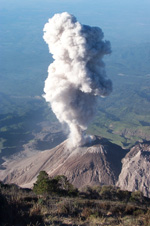 While these appear like questions a 5-year old would ask Daddy, they are questions we are still pondering throughout the research community. What has become clear as that eruptions are driven by expanding bubbles of water vapor (mostly) and also some CO2 (deeper and not as much) and other gases. As a magma decompresses for whatever reason, the water dissolved in the melt exsolves, making tiny bubbles. The details of how bubbles can nucleate when they would have to overcome a potential barrier of virtually infinite surface tension pressure until they grew past a critical size is a big mystery at present. Yet, it happens. A lot.
While these appear like questions a 5-year old would ask Daddy, they are questions we are still pondering throughout the research community. What has become clear as that eruptions are driven by expanding bubbles of water vapor (mostly) and also some CO2 (deeper and not as much) and other gases. As a magma decompresses for whatever reason, the water dissolved in the melt exsolves, making tiny bubbles. The details of how bubbles can nucleate when they would have to overcome a potential barrier of virtually infinite surface tension pressure until they grew past a critical size is a big mystery at present. Yet, it happens. A lot.The result is a bubbly magma that rises and while it does, the bubbles grow further by 1) diffusion of gas through the melt toward and into the bubbles, and 2) decompressive expansion as they are exposed to less pressure shallower in the crust. This can all be modeled numerically, and bubble size distributions as a function of time can be determined for various magma rise histories, nucleation events, magma compositions, and conduit geometries. The validity of the parametric choices can be tested against volcanic rocks such as pumices that preserve the bubbles (called vesicles once they harden in the rock). However, some eruptions are really violent and the explosive growth of the bubbles driving the eruption causes virtually all the bubbles to burst, leaving only the fragments of the bubble walls in the eruption column. These make volcanic ash, rather than pumice or lava flows. However, it turns out that you can measure the curvature of the surfaces of ash particle by using stereoscopic scanning electron microscopy, and form this, estimate the size distribution of the bubbles that were driving these most violent eruptions- the ones that close airports, make pretty sunsets, etc. What happens to the ash once it is blasted into the sky? It falls, but so slowly (it is very small) that the wind can carry it far away, and even circumnavigate the Earth. What controls the time ash can spend in the air? In part it is the size of the particles, in part their chance of getting swept up by a raindrop, and in part, it turns out, by the shape of the ash particles, which is determined by the way the magma fragmented during the eruption. This is being explored now in a large wind tunnel that can “blow” the ash and record its settling time and travel distance for various wind speeds, particle shapes, sizes, and population densities.